Saturday, December 29, 2007

December 2007 Sucia Island paddle


Leaving from Orcas Island in Washington State the day after Christmas my paddling partner and I planned to spend three day's paddling around Sucia Island SP and Patos Island BUT the weather God's had another plan. Leaving on Wednesday from North Beach we paddled under a beautiful blue sky with a light breeze. What a day!! The Canadian mountains in the distance shone brilliantly wrapped in their beautiful winter coat of white. An easy two mile paddle over to Fox Cove on Sucia to set up tents on this sunny afternoon. Finding a campsite was no problem other than the ranger and his family we had the entire island to ourselves. If you ever want to see sand stone formations crafted by thousands of years of wind and waves this is a place to observe that beauity.
Well aware that the weather was going to take a drastic turn towards winter conditions later that evening we were glad to get the tents set up in the sunshine. We did take the opportunity to check out the 10,000+ year old fish, oyster and clam fossils on EV Henry Point. Well worth the hike if you get over to Sucia. Loads of oyster catcher were picking over the rocks on their never ending search for lunch. Eagles, seagulls and cormorants kept us company along with a couple of seals that seemed interested in our presence.
As advertised winter came with a vengeance that evening 30-35 knot winds, snow, sleet and rain as a deep low pressure system passed. Thursday was not a day to paddle so a hike from our campsite up to Ewing Cove on the northeast corner of Sucia was the order of the day. All during our hike the winds were howling and rain was flying sideways but it was a lot warming hiking then setting in a tent reading. Last night was cold and tonight will even be chillier ! Listening to the weather the west end of the Strait of Juan de Fuca had 15+ swell and 5 ft wind waves which was all heading our way for Saturday. A weather window of 15-20 mph winds was forecasted for Friday morning, checking the Washbourne tables also suggested the currents would be favorable around 10am so that was the plan. Friday morning as predicted the wind did subside after another extremely windy, cold night. A few patches of blue sky greeted Friday morning. Packed and on the water by 9:30 the wind was blowing 20 mph out of the west southwest which made the water quite jobbly as we passed between little and big Sucia Islands. Good to get the adrenalin pumping at the beginning of the paddle. A little planning, some warm clothing and a good weather awareness this paddle is a great winter paddle.

Tuesday, December 4, 2007

Deception Pass Dash


The good folks at Seattle Raft and Kayak held their second annual "Deception Pass Dash" on Sunday December 2. An interesting weekend weather wise around this part of the country, 4+ inches of rain after it snowed 6 + inches Saturday, hurricane force winds with 38 ft swell off the coast and I was thinking no way the Dash is going to happen this weekend for the 104 paddlers who signed up for the race. Fortunately the kayak gods were smiling and gave the SRK folks a long enough weather window to get the event in. What fun, under overcast skies, 35 degrees, spitting snow flakes and 10-15kt winds ( and building ) in the pass 76 racers took off at 9:45am. I finished 44th in a death defying time of 88 1/2 minutes to cover the 6 1/2 miles..

Friday, November 9, 2007

Guemes Island Paddle


Another picture perfect Puget Sound day to paddle. Took off this morning at 8:45 launching at a little park next to the Guemes Island ferry dock in Anacortes, WA. My paddling partner and I experienced 15 kt SW winds, dead calm, a lite shower or two and a couple of sunbreaks, a normal Mid November day for this part of the country. We paddled counter clockwise trying to take advantage of the currents on this full moon day. Took a break on Strawberry Island at the Washington Water Trails site which is a beautiful site. Next break we took was at Young Park on the north end of Guemes Island another beautiful park. The park is named after Vietnam war Congressional Medal award honoree. On this leg we saw a very large bull California sea lion fishing for salmon, several pairs of eagles, seals and loads of birds returning for the winter. After the break we headed south and back to our put in arriving at 1:30pm. The Olympic mountains were dazzling as the sun reflected off their new coating of snow. This paddle covered 15.75 statute miles..

Monday, October 15, 2007

Shaw Island, WA Oct 2007


On this beautiful fall day a couple of paddlers circumnavigated Shaw Island in Washington State's San Juan Island group. We launched at the marina in Deer Harbor at 8:15 am under bright blue skies. With the direction of the currents we decided to take full advantage of the flow and head around the west side of Shaw. Not a lot of building on this beautiful island so the waterfront looks faily prestine. A land conservencey along the south and east sides of the island has prevented most development, very much appreciated. As we traveled around the north side of the island we stopped for a break at Blind Island SP which is another nice place for the paddle-powered community to take advantage of. There is also a WWTA site on the island so canoe's and kayakers can camp overnight. We finished our paddle 4 hours and 15 minutes after we started back in Deer Harbor. We traveled 17 1/2 miles.

Thursday, October 4, 2007

Hat (Gedney) Island Paddle


This is a nice 14-15 mile paddle you should try. In the ' off season ' which really never happens for kayakers. This is an easy location IE: short carry from your car to the water, to start a trip. On Sunday, Oct 7 the weather forecast was for 15-20kt gusting to 25 southerly winds so we timed our paddle during an ebb hoping for some big wind waves to play in. We were rewarded with some very stiff wind and waves on the east side of Hat. FYI you can sneak a landing on the north side of the island but landing is frowned upon by the islanders. On our return my paddling partner and I practiced some rolls and rescues for the beach goers who stare in wonder. Well actually they were wondering about our sanity ! One caution is to stay well clear of the Washington State ferries which run between Mukilteo and Clinton.

Monday, September 17, 2007

Successful Circumnavigation of Whidbey Island!

The following post is from an email from Bill who is home safe and sound after what is in my view (Mike) a significant accomplishment.

Up at 4:45 am cooked the oatmeal, drank the coffee and packed all the wet gear as it had rained most of the night.

The boats were packed and we were on our way at 5:45 am with no breeze and a very fine mist falling. Paddling in the darkness they were surprised by the very bright luminescence, each stroke and the boat wake was outlined in a greenish/yellowish glow, How Very Cool !!
As the day broke the predicted 10-15K NM wind did kick in which rapidly propelled them south. The wind waves were 1-2 ft with an occasional 3 footer to aid our surfing lessons.
Stopped briefly at the end of Camano Island of one last refreshment break before we hit the final leg of the journey. We passed to the west of Hat (Gedney) Island and after dodging one big assed pleasure boat they landed at 9:40 am from where the trip started at the Mukilteo waterfront park.
They traveled just over 17 miles today. Test of the trip, the two paddlers are still good friends and planning the next grand adventure !

Camano Island State Park


Bill & Rob arrived at Camano Island after a long days paddle. They left at about 7:30 am and didn't arrive at Camano until 3:30 pm. They had to zig zag their route, to try to avoid paddling into the wind and current. They ended up doing about 25 miles. They crossed from Whidbey Island to Camano Island at Strawberry Point in the rain and fog. It was a very gray day with visability under a mile. They were concerned with all the large power boats traveling home after the weekend. On the east side of Whidbey adjacent to the Navel Air Station there is a long strech of undeveloped shortline which is inhabited by a very large colony of Great Blue Hurons that squawked their approval as Rob and Bill paddled by. All is well and the rain stopped long enough for them to setup a dry camp. They will be back at the starting point of their journey tomorrow.

Sunday, September 16, 2007

Skagit Island


Bill & Rob had a great day of paddling on Saturday with no wind and no fog. They started out at 7:50 am and arrived at Skagit island at 1:15 pm. There was a bit of swell coming down the Strait of Juan de Fuca to keep them alert. The traveled through Deception Pass with some ebb current flowing and had to thread their way through fishing boats making sure they didn't get caught up in their lines. They saw their first kayaker on the water today, there has been little congestion on the water. They camped at the WWTA site on Skagit Island SP and enjoying a gorgeous evening. They assumed the locals were celebrating their arrival on Skagit as there was a polka band playing in the distance that evening and a short fireworks show. Nice touch the locals are friendly. I've included a photo of the Deception pass bridge.

Friday, September 14, 2007

Joseph Whidbey State Park


Bill & Rob arrived safely at Joseph Whidbey State Park as planned and camped at the WWTA site. The plan was to leave the first campsite, paddle the 7 miles up to Keystone Ferry dock, take a break and grab a high fat sugar laced junk food breakfast with lots of coffee but the restrauant was closed..bummer!! Again it was foggy in the morning and then burned off about 1pm. On one stretch the currents were with them and they traveled 7 miles in an hour. Then the next 6 miles took them 2 1/2 hours. They are only about 8 miles from Deception Pass and plan to pass through during slack current. Other than the fog, the weather continues to be favorable with another day of ZERO wind. Fortunately there was a little swell coming down the Strait which created a bit of texture on the water. They saw another group of pelicans today!!( Starting to think Florida !). Bill attributes the mild weather conditions to his wearing his Body Boat Blade hat. I've included a satellite photo of their location.

Thursday, September 13, 2007

Somewhere between Bush Pt. and Lagoon Pt.


Bill & Rob spent most of the day paddling in the fog. The Sound was absolutely flat not a breeze on the water. They could hear the ships in the shipping channel of Puget Sound but were safely on the shore of Whidbey, so it was not a cause of concern. According to Rob's GPS they traveled 21 miles today. They left Mukilteo around 7:40am and got to their camp between Bush and Lagoon Points about 6 hours later. They saw loads of shore birds, porpoise and seals on the trip. Also a first was several pelicans they paddled by today. On one occasion a set of sea lions put on a show, they were jumping out of the water attempting to catch fish.

I've attached a Google Earth satellite photo with a pin showing their approximate location.

Saturday, August 25, 2007

Whidbey Circumnavigation


Planning Sessions: Sept 3 2007: We have had two planning sessions to discuss tides and currents, camping options, 'what if scenarios', shared responsibilities and of course that we are still both comfortable with the chosen route and the mileage required to keep on plan. This information will be captured and shared on our float plan. In preparation for this paddle I have worked a couple of 'on the water' rescues/recoveries sessions and paddled four consecutive days of 15k + paddles just to see how the muscles feel. I don't think the mileage will be a problem although I did feel some tender muscles after the fourth day. During my preparation paddles my focus has been the mental aspect of the paddle, attempting to concentrate on technique and form. Next week I plan a few long paddles, work another rescue/recovery session and finalize float plan details. I think I'm good to go!
I have packed and re-packed for the trip, focusing on minimizing weigth, just taking what's necessary and nothing else.


The Paddle Plan: August 20, 2007 Rob and I will launch from the waterfront park in Mukilteo, Washington on Thursday September 13, 2007 in the 07:00 timeframe and paddle up the westside of Whidbey Island. Paddling the westside first we will get the exposed and longer "trip legs" out of the way. The westside is a bit more tricky as there are a fewer places to camp legally, so we may just have to stroll in at dusk. The east side of the island offers more options to optimize travel should conditions become problematic plus we can take advantage of campsites and bailout points on both Whidbey Island and neighboring Camano Island. We plan on taking five days, enjoying the water, sites, smells and wild life and the freedom from the 'norm' this trip will provide for us. This is not a race (second largest island in the continental United States)for us as every day on the water is one less day parked in an office cube :) .
Day 1 Thursday paddle Mulilteo to Bush Point area.
Day 2 Friday Bush Point to Joseph Whidbey SP.
Day 3 Saturday Joseph Whidbey SP to (thru Deception Pass) Skagit Island.
Day 4 Sunday Skagit Island to Camano Island SP at WWTA site
Day 5 Monday Camano Island SP back to Mukilteo.

Wednesday, August 8, 2007

Vashon & Maury Island Circumnavigation


Departed from the marina in Des Moines at 9:45 a.m. on a 45 degree Friday morning February 16. Paddled the 2+ miles across the Sound to Pt. Robinson on the far eastern shore of Maury Island. Heading southeast along the shoreline we crossed Quartermaster Harbor before turning north into Colvos Passages. We arrived at our planned campsite, the Washington Water Trails Park at Lisabeula on Vashon Island at 2:00 p.m. Tents were up and everything made ready for the night just before the rain started falling. One of the locals shared the very interesting history of how the park was transitioned from an artist colony to a park. First days paddle was about 16 miles.

Saturday’s weather forecast was for a sunny and warm 60-degree morning. Conditions were predicted to change in the early afternoon as a storm front approached carrying with it 30 to 40 mph winds. Leaving Lisabuela at 9:00 a.m. in a light morning fog that almost obscures a brilliant sunrise. The water is perfectly flat as we paddle north. We arrive at the Vashon ferry dock at 10:45 a.m. for a break. The Mexican restaurant at the dock is closed so it will have to be another peanut butter sandwich lunch along the way. Turning south around Dolphin Point, Mt Rainer with two cap clouds hovering over it’s peak stands out brilliantly in the bright sunlight. Following a lunch break at Pt. Heyer, our next stop was at Pt. Robinson, which completed our planned circumnavigation. We arrived in perfectly calm sunny conditions back at the Des Moines Marina at 2:30 in the afternoon. The timing of the weather change was a couple of hours latter than the prediction. At 6:00 p.m. the weather bureau reported wind speeds of 45 knots between Vashon Island and Fauntleroy, was good to be off the water! Total paddle for the two days was approximately 32 miles.

A December Paddle


Tuesday December 26 we arrive at Joemma SP and what luck, no parking problems at all, in fact the parking lot is completely empty!! We launch at 10:30am in a light rain. It is 45 degrees and a 10-15 knot wind is blowing out of the North, so far everything is working to plan. At noon we arrived at Bishop Point at the south end of Hartstene Island where the nice push we enjoyed suddenly ended. We had to put in some extra effort as we crossed Peale Passage to Squaxin Island paddling against the current and wind. As we rounded the south end of Squaxin there were large congregations of wintering birds. Arriving at Hope Island SP around 1:30pm we again were in luck as every campsite on the island was available. After putting up the tents in a steady rain, we jumped back in the boats and paddled around Hope Island and over to the west side of Squaxin Island for some exploring, again the number and variety of wintering birds was impressive. The afternoon and night proved to be a very good test for staying dry. The light rain turned into a driving all-night rain, (Boston Harbor reported 1.75 inches). The first day’s paddle covered 12.3 nm.

Wednesday morning broke with scattered clouds and a forecast of sun for the next two day’s, oh boy! our gear may actually dry out. It doesn’t get light until 7:30am at this time of the year so the boats were packed and back on the water just past the crack of dawn, 10:30am sharp. Today, we paddle into a light northerly breeze launching from Hope Island heading around the south end and up the eastside of Squaxin Island. Squaxin has been wonderfully protected by the Squaxin Indian tribe from development and is for the most part pristine. Eagles, blue herons, cormorant, gulls, kingfishers, ducks, ducks and more ducks abound. At 1:15pm we take a lunch break at the Lattimer Bridge in Pickering Passage. Back on the water at 1:30pm and off to Jerrell Cove SP we go, arriving at 2:35pm. Again we were extremely lucky to find every campsite available. The day is clear and sunny so tonight will be very chilly, temperatures predicted are for the upper 20’s, there is a light coating of frost on the dock and it’s only 4:30 pm!! Jerrell Cove is a beautifully well-maintained park, it had indoor bathrooms and water available but the HOT showers were unfortunately shut off for the season. The second day’s paddling covered 13.1 nm.

Thursday dawns a very cold, 25-degree foggy morning. The moisture from last night’s fog has left a frozen glaze on everything. With the aid of a hot breakfast and several cups of hot coffee to knock the chill off, we complete the hand numbing cold task of packing the tents this morning. We are on the water at 9:30am in a breeze-less foggy morning. Soon the fog begins to burn off revealing a bright blue sky. We arrive at McMicken Island SP at 11:15am for a quick break and a little exploring. At 11:30am we are back on the water heading for our starting and ending destination, Joemma Beach SP. Mt. Rainier is in perfect alignment with our destination and looks brilliant in the winter sun, a perfect ending to three fun filled paddling days. The final day’s paddle covered 11.2nm.

Sunday, August 5, 2007

Paddling & the Blue Angles

Had a great day on Lake Washington Saturday August 4th. Ten Washington Kayak Club paddlers practiced our rolls, recoveries, rescues, wet exits and a variety of strokes for two and a half hours under 75 degree bright blue skies. This is a slice of heaven !! After our practice session we took a break and a quick picnic lunch then it was back on the water and a 1/4 miles paddle off the northwest end of Mercer Island to watch the Blue Angles perform their magic. I get goosebumps every time I see them perform and to be so close on their fly over's is a real noisy treat! Go America !!

Saturday, July 28, 2007

Splash and Thrash

Kayakers,

If your interested in trying your rolls, recoveries etc there is a group of us meet every Thursday afternoon around 4 PM on the north side of Mercer Island (East of Seattle) at Lincoln Landing. Your most welcome to join us.
Here's directions to Lincoln Landing: heading west on I90,take the 2nd Mercer Island exit (Island Way). At theexit continue straight through the lights past thepark n ride, etc. until you come to the stop sign at76th (if you continued straight here you would go backonto the freeway). Turn right and immediately right again, then immediately left into the road end park(76th and 22nd).

Sunday, July 22, 2007

July 14 Washington Park to Friday Harbor


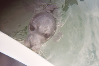
A group of WKC paddlers took off from Washington Park (Anacortes, WA) on a bright summer day. The current down Rosario Strait quickly took us to the southeast side of Lopez Is, WA. Three hours after we launched we were at Iceburg Point having lunch with another group of paddlers. After a nice sunny lunch on a log, the 7 singles and two double kayaks headed to Cattle Pass and it's 5.4 kt currents and whirlpools. We arrived in Friday Harbor at 3:15pm just enough time to grab a quick beer and jump on the ferry. Great day and a good first time experience for 5 of the paddlers. A first time event for me: as we passed Turn Island just outside of Friday Harbor my boat was mistaken for a mother by this just born seal pup.. " did have it's fathers eyes"...