Saturday, August 25, 2007

Whidbey Circumnavigation


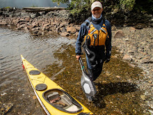
Planning Sessions: Sept 3 2007: We have had two planning sessions to discuss tides and currents, camping options, 'what if scenarios', shared responsibilities and of course that we are still both comfortable with the chosen route and the mileage required to keep on plan. This information will be captured and shared on our float plan. In preparation for this paddle I have worked a couple of 'on the water' rescues/recoveries sessions and paddled four consecutive days of 15k + paddles just to see how the muscles feel. I don't think the mileage will be a problem although I did feel some tender muscles after the fourth day. During my preparation paddles my focus has been the mental aspect of the paddle, attempting to concentrate on technique and form. Next week I plan a few long paddles, work another rescue/recovery session and finalize float plan details. I think I'm good to go!
I have packed and re-packed for the trip, focusing on minimizing weigth, just taking what's necessary and nothing else.


The Paddle Plan: August 20, 2007 Rob and I will launch from the waterfront park in Mukilteo, Washington on Thursday September 13, 2007 in the 07:00 timeframe and paddle up the westside of Whidbey Island. Paddling the westside first we will get the exposed and longer "trip legs" out of the way. The westside is a bit more tricky as there are a fewer places to camp legally, so we may just have to stroll in at dusk. The east side of the island offers more options to optimize travel should conditions become problematic plus we can take advantage of campsites and bailout points on both Whidbey Island and neighboring Camano Island. We plan on taking five days, enjoying the water, sites, smells and wild life and the freedom from the 'norm' this trip will provide for us. This is not a race (second largest island in the continental United States)for us as every day on the water is one less day parked in an office cube :) .
Day 1 Thursday paddle Mulilteo to Bush Point area.
Day 2 Friday Bush Point to Joseph Whidbey SP.
Day 3 Saturday Joseph Whidbey SP to (thru Deception Pass) Skagit Island.
Day 4 Sunday Skagit Island to Camano Island SP at WWTA site
Day 5 Monday Camano Island SP back to Mukilteo.

Wednesday, August 8, 2007

Vashon & Maury Island Circumnavigation


Departed from the marina in Des Moines at 9:45 a.m. on a 45 degree Friday morning February 16. Paddled the 2+ miles across the Sound to Pt. Robinson on the far eastern shore of Maury Island. Heading southeast along the shoreline we crossed Quartermaster Harbor before turning north into Colvos Passages. We arrived at our planned campsite, the Washington Water Trails Park at Lisabeula on Vashon Island at 2:00 p.m. Tents were up and everything made ready for the night just before the rain started falling. One of the locals shared the very interesting history of how the park was transitioned from an artist colony to a park. First days paddle was about 16 miles.

Saturday’s weather forecast was for a sunny and warm 60-degree morning. Conditions were predicted to change in the early afternoon as a storm front approached carrying with it 30 to 40 mph winds. Leaving Lisabuela at 9:00 a.m. in a light morning fog that almost obscures a brilliant sunrise. The water is perfectly flat as we paddle north. We arrive at the Vashon ferry dock at 10:45 a.m. for a break. The Mexican restaurant at the dock is closed so it will have to be another peanut butter sandwich lunch along the way. Turning south around Dolphin Point, Mt Rainer with two cap clouds hovering over it’s peak stands out brilliantly in the bright sunlight. Following a lunch break at Pt. Heyer, our next stop was at Pt. Robinson, which completed our planned circumnavigation. We arrived in perfectly calm sunny conditions back at the Des Moines Marina at 2:30 in the afternoon. The timing of the weather change was a couple of hours latter than the prediction. At 6:00 p.m. the weather bureau reported wind speeds of 45 knots between Vashon Island and Fauntleroy, was good to be off the water! Total paddle for the two days was approximately 32 miles.

A December Paddle


Tuesday December 26 we arrive at Joemma SP and what luck, no parking problems at all, in fact the parking lot is completely empty!! We launch at 10:30am in a light rain. It is 45 degrees and a 10-15 knot wind is blowing out of the North, so far everything is working to plan. At noon we arrived at Bishop Point at the south end of Hartstene Island where the nice push we enjoyed suddenly ended. We had to put in some extra effort as we crossed Peale Passage to Squaxin Island paddling against the current and wind. As we rounded the south end of Squaxin there were large congregations of wintering birds. Arriving at Hope Island SP around 1:30pm we again were in luck as every campsite on the island was available. After putting up the tents in a steady rain, we jumped back in the boats and paddled around Hope Island and over to the west side of Squaxin Island for some exploring, again the number and variety of wintering birds was impressive. The afternoon and night proved to be a very good test for staying dry. The light rain turned into a driving all-night rain, (Boston Harbor reported 1.75 inches). The first day’s paddle covered 12.3 nm.

Wednesday morning broke with scattered clouds and a forecast of sun for the next two day’s, oh boy! our gear may actually dry out. It doesn’t get light until 7:30am at this time of the year so the boats were packed and back on the water just past the crack of dawn, 10:30am sharp. Today, we paddle into a light northerly breeze launching from Hope Island heading around the south end and up the eastside of Squaxin Island. Squaxin has been wonderfully protected by the Squaxin Indian tribe from development and is for the most part pristine. Eagles, blue herons, cormorant, gulls, kingfishers, ducks, ducks and more ducks abound. At 1:15pm we take a lunch break at the Lattimer Bridge in Pickering Passage. Back on the water at 1:30pm and off to Jerrell Cove SP we go, arriving at 2:35pm. Again we were extremely lucky to find every campsite available. The day is clear and sunny so tonight will be very chilly, temperatures predicted are for the upper 20’s, there is a light coating of frost on the dock and it’s only 4:30 pm!! Jerrell Cove is a beautifully well-maintained park, it had indoor bathrooms and water available but the HOT showers were unfortunately shut off for the season. The second day’s paddling covered 13.1 nm.

Thursday dawns a very cold, 25-degree foggy morning. The moisture from last night’s fog has left a frozen glaze on everything. With the aid of a hot breakfast and several cups of hot coffee to knock the chill off, we complete the hand numbing cold task of packing the tents this morning. We are on the water at 9:30am in a breeze-less foggy morning. Soon the fog begins to burn off revealing a bright blue sky. We arrive at McMicken Island SP at 11:15am for a quick break and a little exploring. At 11:30am we are back on the water heading for our starting and ending destination, Joemma Beach SP. Mt. Rainier is in perfect alignment with our destination and looks brilliant in the winter sun, a perfect ending to three fun filled paddling days. The final day’s paddle covered 11.2nm.

Sunday, August 5, 2007

Paddling & the Blue Angles

Had a great day on Lake Washington Saturday August 4th. Ten Washington Kayak Club paddlers practiced our rolls, recoveries, rescues, wet exits and a variety of strokes for two and a half hours under 75 degree bright blue skies. This is a slice of heaven !! After our practice session we took a break and a quick picnic lunch then it was back on the water and a 1/4 miles paddle off the northwest end of Mercer Island to watch the Blue Angles perform their magic. I get goosebumps every time I see them perform and to be so close on their fly over's is a real noisy treat! Go America !!