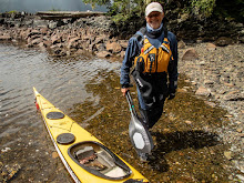
The following post is from an email from Bill who is home safe and sound after what is in my view (Mike) a significant accomplishment.
Up at 4:45 am cooked the oatmeal, drank the coffee and packed all the wet gear as it had rained most of the night.
The boats were packed and we were on our way at 5:45 am with no breeze and a very fine mist falling. Paddling in the darkness they were surprised by the very bright luminescence, each stroke and the boat wake was outlined in a greenish/yellowish glow, How Very Cool !!
As the day broke the predicted 10-15K NM wind did kick in which rapidly propelled them south. The wind waves were 1-2 ft with an occasional 3 footer to aid our surfing lessons.
Stopped briefly at the end of Camano Island of one last refreshment break before we hit the final leg of the journey. We passed to the west of Hat (Gedney) Island and after dodging one big assed pleasure boat they landed at 9:40 am from where the trip started at the Mukilteo waterfront park.
They traveled just over 17 miles today. Test of the trip, the two paddlers are still good friends and planning the next grand adventure !
Monday, September 17, 2007


Camano Island State Park


Bill & Rob arrived at Camano Island after a long days paddle. They left at about 7:30 am and didn't arrive at Camano until 3:30 pm. They had to zig zag their route, to try to avoid paddling into the wind and current. They ended up doing about 25 miles. They crossed from Whidbey Island to Camano Island at Strawberry Point in the rain and fog. It was a very gray day with visability under a mile. They were concerned with all the large power boats traveling home after the weekend. On the east side of Whidbey adjacent to the Navel Air Station there is a long strech of undeveloped shortline which is inhabited by a very large colony of Great Blue Hurons that squawked their approval as Rob and Bill paddled by. All is well and the rain stopped long enough for them to setup a dry camp. They will be back at the starting point of their journey tomorrow.
Sunday, September 16, 2007
Skagit Island


Bill & Rob had a great day of paddling on Saturday with no wind and no fog. They started out at 7:50 am and arrived at Skagit island at 1:15 pm. There was a bit of swell coming down the Strait of Juan de Fuca to keep them alert. The traveled through Deception Pass with some ebb current flowing and had to thread their way through fishing boats making sure they didn't get caught up in their lines. They saw their first kayaker on the water today, there has been little congestion on the water. They camped at the WWTA site on Skagit Island SP and enjoying a gorgeous evening. They assumed the locals were celebrating their arrival on Skagit as there was a polka band playing in the distance that evening and a short fireworks show. Nice touch the locals are friendly. I've included a photo of the Deception pass bridge.
Friday, September 14, 2007
Joseph Whidbey State Park

 Bill & Rob arrived safely at Joseph Whidbey State Park as planned and camped at the WWTA site. The plan was to leave the first campsite, paddle the 7 miles up to Keystone Ferry dock, take a break and grab a high fat sugar laced junk food breakfast with lots of coffee but the restrauant was closed..bummer!! Again it was foggy in the morning and then burned off about 1pm. On one stretch the currents were with them and they traveled 7 miles in an hour. Then the next 6 miles took them 2 1/2 hours. They are only about 8 miles from Deception Pass and plan to pass through during slack current. Other than the fog, the weather continues to be favorable with another day of ZERO wind. Fortunately there was a little swell coming down the Strait which created a bit of texture on the water. They saw another group of pelicans today!!( Starting to think Florida !). Bill attributes the mild weather conditions to his wearing his Body Boat Blade hat. I've included a satellite photo of their location.
Thursday, September 13, 2007
Somewhere between Bush Pt. and Lagoon Pt.

Bill & Rob spent most of the day paddling in the fog. The Sound was absolutely flat not a breeze on the water. They could hear the ships in the shipping channel of Puget Sound but were safely on the shore of Whidbey, so it was not a cause of concern. According to Rob's GPS they traveled 21 miles today. They left Mukilteo around 7:40am and got to their camp between Bush and Lagoon Points about 6 hours later. They saw loads of shore birds, porpoise and seals on the trip. Also a first was several pelicans they paddled by today. On one occasion a set of sea lions put on a show, they were jumping out of the water attempting to catch fish.
I've attached a Google Earth satellite photo with a pin showing their approximate location.
Saturday, August 25, 2007
Whidbey Circumnavigation

Planning Sessions: Sept 3 2007: We have had two planning sessions to discuss tides and currents, camping options, 'what if scenarios', shared responsibilities and of course that we are still both comfortable with the chosen route and the mileage required to keep on plan. This information will be captured and shared on our float plan. In preparation for this paddle I have worked a couple of 'on the water' rescues/recoveries sessions and paddled four consecutive days of 15k + paddles just to see how the muscles feel. I don't think the mileage will be a problem although I did feel some tender muscles after the fourth day. During my preparation paddles my focus has been the mental aspect of the paddle, attempting to concentrate on technique and form. Next week I plan a few long paddles, work another rescue/recovery session and finalize float plan details. I think I'm good to go!
I have packed and re-packed for the trip, focusing on minimizing weigth, just taking what's necessary and nothing else.
The Paddle Plan: August 20, 2007 Rob and I will launch from the waterfront park in Mukilteo, Washington on Thursday September 13, 2007 in the 07:00 timeframe and paddle up the westside of Whidbey Island. Paddling the westside first we will get the exposed and longer "trip legs" out of the way. The westside is a bit more tricky as there are a fewer places to camp legally, so we may just have to stroll in at dusk. The east side of the island offers more options to optimize travel should conditions become problematic plus we can take advantage of campsites and bailout points on both Whidbey Island and neighboring Camano Island. We plan on taking five days, enjoying the water, sites, smells and wild life and the freedom from the 'norm' this trip will provide for us. This is not a race (second largest island in the continental United States)for us as every day on the water is one less day parked in an office cube :) .
Day 1 Thursday paddle Mulilteo to Bush Point area.
Day 2 Friday Bush Point to Joseph Whidbey SP.
Day 3 Saturday Joseph Whidbey SP to (thru Deception Pass) Skagit Island.
Day 4 Sunday Skagit Island to Camano Island SP at WWTA site
Day 5 Monday Camano Island SP back to Mukilteo.
Wednesday, August 8, 2007
Vashon & Maury Island Circumnavigation


Departed from the marina in Des Moines at 9:45 a.m. on a 45 degree Friday morning February 16. Paddled the 2+ miles across the Sound to Pt. Robinson on the far eastern shore of Maury Island. Heading southeast along the shoreline we crossed Quartermaster Harbor before turning north into Colvos Passages. We arrived at our planned campsite, the Washington Water Trails Park at Lisabeula on Vashon Island at 2:00 p.m. Tents were up and everything made ready for the night just before the rain started falling. One of the locals shared the very interesting history of how the park was transitioned from an artist colony to a park. First days paddle was about 16 miles.
Saturday’s weather forecast was for a sunny and warm 60-degree morning. Conditions were predicted to change in the early afternoon as a storm front approached carrying with it 30 to 40 mph winds. Leaving Lisabuela at 9:00 a.m. in a light morning fog that almost obscures a brilliant sunrise. The water is perfectly flat as we paddle north. We arrive at the Vashon ferry dock at 10:45 a.m. for a break. The Mexican restaurant at the dock is closed so it will have to be another peanut butter sandwich lunch along the way. Turning south around Dolphin Point, Mt Rainer with two cap clouds hovering over it’s peak stands out brilliantly in the bright sunlight. Following a lunch break at Pt. Heyer, our next stop was at Pt. Robinson, which completed our planned circumnavigation. We arrived in perfectly calm sunny conditions back at the Des Moines Marina at 2:30 in the afternoon. The timing of the weather change was a couple of hours latter than the prediction. At 6:00 p.m. the weather bureau reported wind speeds of 45 knots between Vashon Island and Fauntleroy, was good to be off the water! Total paddle for the two days was approximately 32 miles.
Subscribe to:
Posts (Atom)