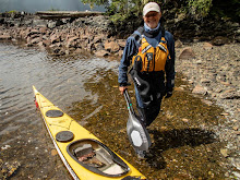
This trip to Balaclava Island and the God's Pocket area was a trip I co-lead with a group of NSSKA kayak club members, several of whom had not done a wilderness trip. Prior to this trip the group held a planning meeting to review individual responsibilities, develop our trip plan, paddle plan and our travel plans to Port Hardy, British Columbia, Canada.
Saturday July 6, 2019: Group members made their way to Port Hardy then we visited the local museum, coffee shops, bakery and lone grocery store. Late afternoon the group assembled at Sporty's Bar & Grill to firm up the next day's launch time, launch location (Carrot Park), review segment trip leaders and parking for the trip.
Sunday July 7: The 9 person group hit the water at 07:30 under fair skies and calm winds. Our first set of leaders took us to Duval Point then a left turn as we journeyed along the east coast of Vancouver Island up Goletas Channel to Songhees Creek arriving at 09:45. This is a beautiful location with a year round water supply and plenty of camping space for a larger group. Mother bear and her cub greeted us upon our arrival. The bear family worked the hightide line for the entire time we were on the beach, very cool !! The plan is to have our second set of leaders take us across the 2 1/2 mile wide Goletas Channel to our planned camp site at Nolan Point. Nolan Point will serve as our home base from which we will do day paddles for the trips duration. Although there was blue skies above, the channel was covered in a very dense sea fog which began to lift after an hour beach rest. Once the fog began to lift we could see the top's of Nigei, Balaclave, Hurst and Bell Island to the east of our position on Songhees Creek. Our leaders took us to the Nobel Islets then adjusted our course to Nolan Point. Once at Balaclava Island the very popular Nolan Point campsite was being utilized by a group of paddlers so we journeyed up Browning Passage and our campsite under a huge canopy of conifer trees. We spread out our tents, set up the group cooking tarps and had our home sweet home established at 12:45 pm. ( roughly 11 1/2 miles of paddling).
Monday July 8:We were awaken by the shrill squawking of a group of juvenile ravens who for the duration of our stay spent their EARLY mornings whining at their parents for breakfast. Lots of eagles also inhabit this location. Also noticeable was wolf scat along the game trails which cover the island. There are no bears that inhabit permanently, as I understand from the local lighthouse keeper they ate all the deer years before. The sea wolves are a subspecies that have adapted their diet to include the abundance of clams, oysters and muscles which line the islands shores. Today our paddle will be a clockwise circumnavigation of Balaclave Island with a stop/visit at the Scarlett Point lighthouse. Once at the lighthouse the longtime light keeper Ivan and his assistant gave us the grand tour ( they really do like visitors ) We left Ivan with a big batch of homemade cookies and a bottle of spiced rum. ( we have a friend forever!) Back in our kayaks we were immediately greeted by a large group of porpoise and a humpback whale. Our journey down Christie Passage was very pleasant, we could see the God's Pocket resort on Hurst Island as we headed back to our campsite. Several of us (we pre purchased BC fishing licenses) tried our fishing luck in Browning Passage catching several rock cod which we released after bragging to our fellow paddlers. ( roughly 9 miles of paddling)
Tuesday July 9: Today we paddled around the south end of Balaclava Island crossed Christie Passage over to the God's Pocket resort on Hurst Island. No visible activity at the resort so we lined up our boats in front of the colorful cottages took our obligatory pictures and moved on. Paddled clockwise around the rugged coastline to Harlequin Bay where we stopped for lunch. This bay is well protected and has several campsites but the bay is shallow and at low tide it can be a muddy slog out to the deeper water. Again we saw numerous whales, porpoise and sea otters on our journey.
( 10 1/2 miles of paddling ).
Wednesday July 10: Today is our "water run" day to a local water source at Clam Cove on Nigei Island. ( note: yesterday late afternoon and most of the night we had a steady light rain so we where able to capture all the water we needed). This is a paddle exposed to Queen Charlotte Strait and it can be challenging depending on wind speed and direction. Our paddle took us up Browning Channel to Gordon Channel and into Queen Charlotte Sound. Clan Cove is a protected mile long bay with a fish camp and anchoring spot for large fishing and pleasure boats. The water supply is from a creek which drains from a lake and is located at the end of the bay on the right hand side. On our return to camp we paddled along Browning Wall (Google it) with its rich and diverse collection of sea creatures. We had a humpback calf entertain us with some up close and personal dives. (@an 8 mile paddle)
Thursday July 11: Today we paddled along the exposed side of Lucan and Jerome Island on our way to Port Alexander which is a deep mile long bay on Nigei Island with a beautiful, nothing there but sand, rocks and a pine tree lined beach. We waited for slack tide by having a nice sunny lunch break and hike along the black shale beach. Then off we went to Browning Wall for a super slow paddle to admire amazing variety of sea life that covers this steep rock wall. Dozens of colorful sea stars, anemones, mussels, snails, translucent seaweeds, fish, kelp, sea fans and many, many more unique plants and animals make their homes here. We where also visited by a large grey whale that made several passes close to us. Just too cool !! ( paddled @ 7 miles )
Friday July 12: Say it isn't so... we just got here and it's time to head back to Port Hardy. Our third set of leaders have us up packed up and ready to launch at 07:30. It is a nice calm morning, with high overcast skies and no sea fog as we journey back to Songhees Creek. Numerous porpoise travel along with us occasionally surfacing amongst our group. After a snack and bio break at Songhees Creek our final set of trip leaders take command and have us doing a shore crawl as we make our way back to Nolan Point and then onto civilization in Port Hardy. ( again a 11 1/2 mile paddle).
Monday, March 2, 2020
Subscribe to:
Comments (Atom)