Bella Bella 2017 Trip Report
The big plan: The 3 of us,
Rob Freelove, Chris Smith and myself will meet at 5:30 am in Kirkland WA on
July 29th for the drive to the US/Canadian Peace Arch border crossing then to
the Tsawassen BC ferry terminal. Take the BC ferry to Nanimo BC (Duke Pt) then
drive the 5 1/2 hours to Port Hardy, BC.
Spend July 30th in Port Hardy, make all parking arrangements, acquire
any additional food items, pay for the Port Hardy to Bella Bella ferry ride (
make sure you make reservation long in advance for this ferry run). We have
reservation for the 7/31 7:30 am ferry to Bella Bella (note: good to be at the ferry office when they open
at 4:00 AM, parking is first come first serve, cost was $50 cad). Get off the
ferry after a 5 hour ride and paddle to camp site #1. Paddle 8 days and return
to Bella Bella for the ferry ride back to Port Hardy on August 7th.
July 31:
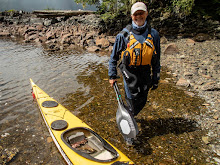
Under unusually warm (actually hot) sunny skies we got off the ferry at 1:30
ish, packed our boats ( very convenient, load and launch site right beside the
ferry dock). I'll mention if you coordinate with the BC ferry folks they will
have a kayak rack and cargo dolly available so we did not have to take our
wheels with us, a nice bonus not having to lash wheels to our boats.
We paddled north past
downtown Bella Bella, a beautiful light house, several totem poles and
Shearwater for 2 hours and 15 minutes to our first campsite at Kynumpt Harbour
(lat 52* 12.203 lng 128* 10.296). Nice relatively isolated camp site, had a
couple sail boats moored in the harbor, plenty of room to camp close to the
beach and in the woods. At low tide you could walk for approximately a mile
along the shore line and there were several trails to hike inland. This was a former village site. Saw a giant
Pacific octopus, a first for me in the wild. Several humpbacks patrolled the
outer edge of the bay, slamming their flukes time and time again, sounded like
cannons going off in the distance. Sadly
again this year there are massive forest fires in BC which of course create a
smoky haze in the air. We are well west of the fires so the only evidence of
the fires we experience are amazing
blood red sun rises.
Aug 1: This
morning under clear blue sunny skies we are on the water at 8:00 am paddling
west down Seaforth Channel towards the Pacific Ocean and our second camp site on
Athlone Island which is located at Yaaklele Entrance (lat 52* 13.256 lng
128*26.367).
The ocean is relatively
calm, low swell and there isn't much of a wind which made for easy paddling conditions.
Lot's for islets, big rocks, channels to cut thru and play around which we
discovered was the case for most of our trip. Our research suggested this campsite
is "well-protected" and it was. We paddled past it for a mile plus
before we dugout the GPS, turned around and went back north before we found the
channel into a small inland lagoon and a great campsite. We did see fresh bear scat here on our walks
around the campsite but never saw the bear(s). Had to watch out for the
abundance of blooming Devil's Club. Arrived at our campsite at 2:05 pm. Note:
on our journey down Seaforth Channel we stop several times to poke around on
remote people-less beaches, at Dennison Point there was a fast running stream which
we may visit on our return leg.
Aug 2:This
morning AGAIN under clear blue sunny skies we are on the water at 6:45 am for a
2 1/2 hour paddle south to our next campsite which is located at Cape Mark (lat
52*9.115 lng 128* 31.858). Lots of fishermen on the flat ocean today, guessing
the fish camp resort close to Wurtele Island has lots of guests this time of
year. We see loads of salmon jumping as
we paddle south, first along the open coast then on the protected east side of
Wurtele Island. Quite possibly the pretties campsite I have ever camped on. We
immediately decide we are staying two nights here... and discussed spending the
rest of our trip here ;-). Cape Mark is on a small island south south west of
Wurtele Island, the west side if fully exposed to the Pacific Ocean and has all
the scars from the winter storms that beat on it, while the east side of the
island is well protected. Beautiful
sandy beaches, enough camping
places for a half dozen tents to spread out on.
With tents up and empty, light boats two of us go for a ride on the west
side of the island. We go from flat calm protected waters to the 2+ meter swell
and fairly stiff winds on the west side of the island, gets the adrenalin flowing
with accompanying pucker factor in a heartbeat. Lots of sea otters watch with amusement. Since
I purchased a BC fishing license I tried my luck at jigging along the rocky
shore..all the fish where quite safe and neither the fish or I got hurt. We saw
several small islets covered with purple flowers, and a large number of sea otters, ravens, crows, loons, eagles,
osprey, river otter population. Tonight
we share the island with John who is on a solo adventure from Ketchikan to Port
Hardy. Small world, he gets boat repairs done with the same person most of us
use, Rhonda.
Aug 3: Again this morning we have beautiful sunny blue skies. We say
goodbye to John as he heads eastward towards Goose Island. We paddle our light
boats over to Edwards Point Bay to check out the water flow at a seasonal creek
at this campsite. Huge 1/2 mile wide fine sandy beach greets us along with
ancient sounding Sand Hill cranes and
flocks of sand pipers working the water's edge for a meal. There is a good flow
out of a creek, so tomorrow we will stop here to re-fill our dromedary bags.
There is a still a stiff breeze today and a good deal of ocean swell, all fun
to paddle in. Easy to paddle directly into the wind or hide behind the myriad
of islands in the area. We paddle from 8:15 am until 1:00 pm probably covered
10 miles exploring this rugged remote area.
Aug 4: Yes,
again the day is gorgeous, blue sunny skies and the wind from the past couple
days is gone. Our plan is to get our water supply refreshed at Edwards Point
Bay then check out the campsite on Cree Point.
Camping there will make our
exploration of Gale Passage logistically easier. Gale Passage has several tidal
rapids and water flows from the north and south at flood tide into a large
lagoon making for fun whirlpools, upwelling and strong currents to play in.
Cree Point, we discover would work only in the most desperate of times. Small
confided bay with few camping options so we decide the Heiltsuk first nation
public cabin at Quinoot Point will be our next campsite. Nice cabin, bunks to
sleep six, stove and quite comfortable. Chris decides he's going to use the cabin,
Rob and I opt to use our tents cuz it just really too warm in the cabin. This
is a youth camp for the Heiltsuk people, with plenty of places to camp and
since they were not there anyone can use the cabin or camp. Left Cape Mark at
9:15 am and arrived at the cabin at 1:35pm. We will stay at this location for
two days.
Aug 5:This will
be a fun day with empty boats and the longest paddle of our trip. Leaving our
campsite we paddle thru a narrow cut at Quinoot Point, by far one of the most
dense and bio-diverse areas of underwater sea life we will see. Scallops,
clams, snails, mussels, crabs, and starfish of every color of the rainbow, sea
urchins, sea anemones, huge collection of sea cucumber and so many more sea
creatures occupy this narrow cut with
its fast moving water. Gale Passage is situated between Athlone Island to the
west and Dufferin Island to the east. We paddle along the southeast side of
Dufferin Island which has steep drop offs to very deep water right along the
walls of the rocky shoreline. So many sea creature cling to the rocks, what a
amazing show. We paddle along the
shoreline where we find numerous creeks flowing into the sea. Stopped by a
anchored pleasure boater cooking breakfast, you can really smell bacon cooking
a long way off and no he didn't offer us any. We are paddling with the current
into a large tide rapids, stopped there for a half hour to play in the currents
before moving on north into a mile long lagoon. Again on a flood tide, water
flows into this lagoon from both the north and south, so we know once we move
into the lagoon we are going to be there for a while. Paddled north to the
tidal rapid on the far north side of the lagoon where our journey ended for the
next hour and a half while the water filled in at an eye opening rate, first a
trickle, then a stream, then a flood. Lunch and naptime.... After lunch and
rummaging thru what appeared to be an abandoned meth cooking operation we
paddled back to the southernmost tidal rapid, and yes we miss-guessed slack so
we needed all our horsepower to get out of the rapids.. well worth the effort
to paddle Gale Passage. When we arrived
back at our campsite we met four ladies who were nearing the end of a multi
week journey. Fun chat on the beach about theirs and our adventures. Discussed
camping options to the north and they decided they would move on and we would
meet up again at the BC ferry dock. A humorous note while the ladies were
preparing to leave one lady announced that unless we wanted to watch the four
of them pee ....The three of us disappeared immediately ;-).
Aug 6: For
the first time on this trip the day is slightly overcast, a good day to move to
our last campsite which as it turned out was also our first campsite. Leaving
the cabin and paddling in calm, flat water we journeyed northeast up Joassa Channel. Rait Narrows is
advertized to be a point where boats should be cautious because of fast moving
water and submerged rocks. Probably good advice for the fishing and sail boats that navigate this narrow
channel however not a problem for sea kayaks.
We stop by the campsite at Hose Pt we suggested to the ladies the day
before and visited with them before moving on to our campsite at Kynumpt
Harbor. After setting up our tents a pair of ravens joined us, seems these two
had visited kayakers campsite before and knew there may be a handout or a good
place to swipe a meal. Around 6 pm a group of four kayakers came by to check
out the camping but decided to stay to camp a 1/2 mile away from us at the
outside of the bay. One very cool animal we saw in the tide line was a large
number of bright blue shrimp, I had never seen blue shrimp before. Paddled two
hours and 45 minutes today.
Aug 7: Up
kind of early for the trip back to Bella Bella and our 6 pm ride back to Port
Hardy. Took our time paddling back, checked out the light house at Waglisla
,toured the busy waterfront of Bella Bella and the towns docks. Back at the BC
Ferry Dock at McLoughlin Bay in about 2 hours and 15minutes. We unpack, lug
boats and gear up to the terminal, change cloths. We have 4 hours to kill so we
walk the mile and 1/2 into Bella Bella. Not much going on in this town of about
1,200 in habitants. Toured the grocery/liquor store which will soon be replaced
by a brand new and much larger store. Another stop well worth the visit is the
'Qatuwas Legacy Project and the new Gathering House. A young man gave us the
history of the town, tribes and goals for the Legacy Project. They have one
very large carved dugout canoe, and several painting under roof.
Heading back to the ferry
dock a nice lady gave us a ride, very nice people. At 4 pm the ferry arrived,
paid for our tickets ( remember good idea to have reservation both legs of this
ferry ride. Because of the forest fires to the east all scheduled airlines
trips were cancelled and everyone needing a ride had go on the ferry). Once on
the ferry the first stop, the dining room, good food, cold beer and no bugs of
any kind joining you for dinner ;-).
Aug 8:
Downtown Port Hardy and the Capt Hardy's restaurant a must stop for breakfast.
On our day of rest we travelled to Coal Harbor to visit the museum. I have been
there before and this is another stop well worth your time. Joel, the care
taker, boss, worker, owner ect is a treat to chat with. The building is a WW2
Canadian air force hanger and under its roof there are airplane parts of all
kinds, boats, telephone gear from way back, a 1950 beautifully restored fire
engine, a Model T, whaling gear and some interesting pictures from the whaling
industry(eat lunch before you look at those), a massive set of blue whale jaw
bones, a metal shop, woodworking shop, these guy's make a lot of the tools they
need for their various restoration projects. .
Aug 9: Up
and on our way at 4:30 am to catch the 12:30 BC ferry back to Tsawassen BC and
the end of another beautiful trip to the British Canadian west coast.